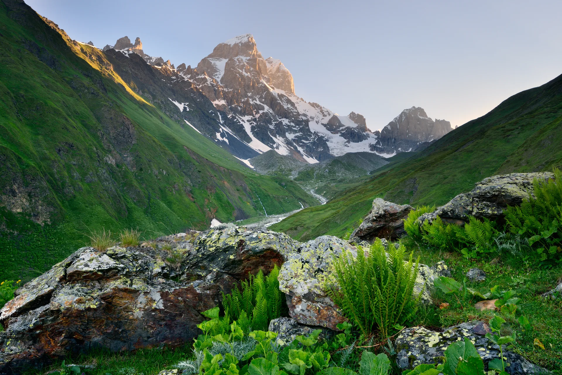
Why Georgia Is a Hiker's Paradise
The numbers speak first: Georgia packs 14 mountain ranges into a country smaller than South Carolina. The Greater Caucasus forms the northern border, with peaks above 5,000 meters. Below that, you get alpine meadows, glacier valleys, medieval villages, dense forests, and — this is the important part — almost nobody on the trail.
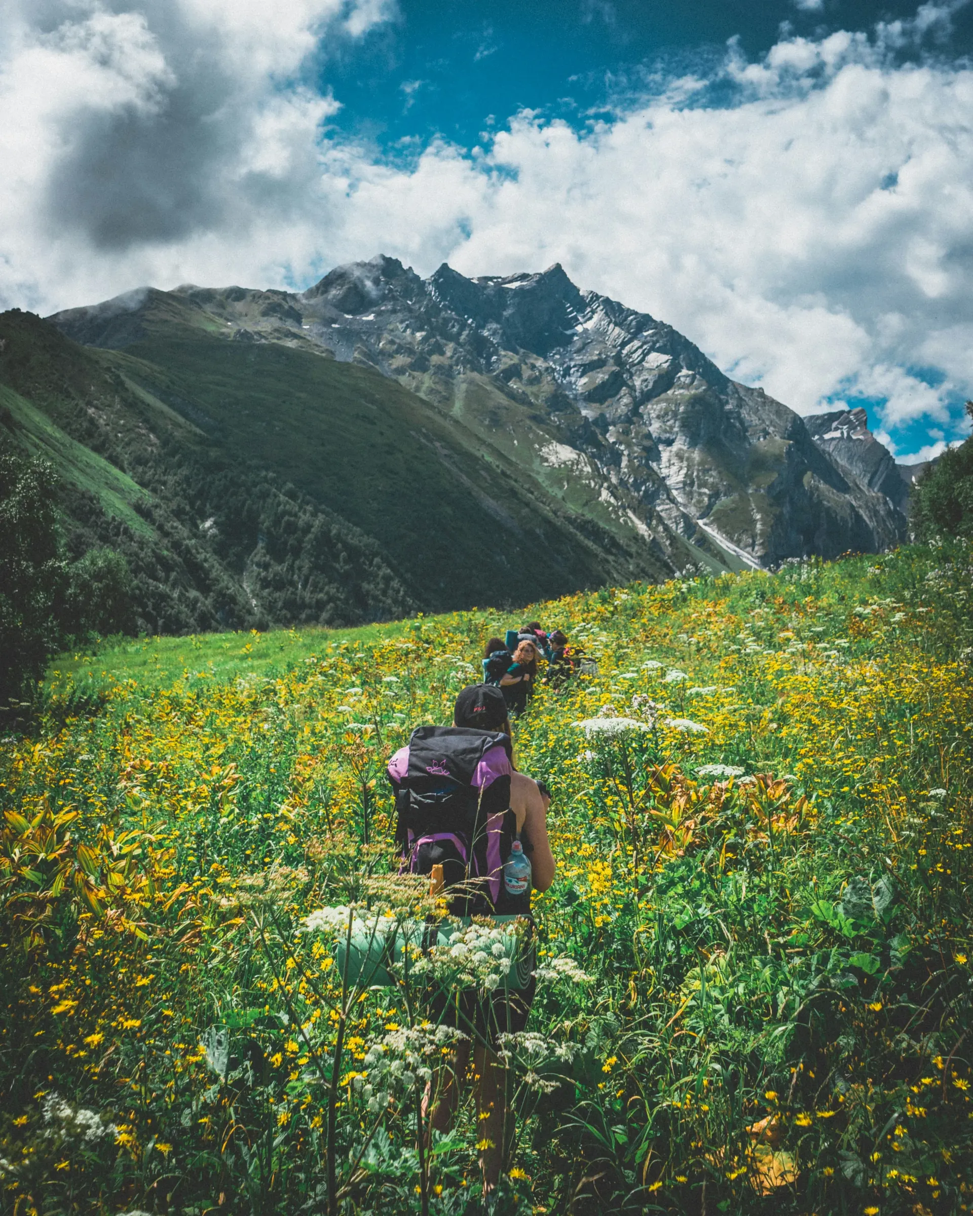
Compared to the Alps, where popular routes feel like a highway in August, Georgia's trails are deserted. The Mestia to Ushguli trek, arguably the most famous hike in the country, might see a few dozen people on a busy day. The off-beat routes? You could go an entire day without encountering another soul.
The infrastructure is improving but still basic. That's both the appeal and the challenge. You won't find staffed mountain huts with hot meals at every pass. What you will find is genuine wilderness, unbelievable hospitality in village guesthouses, and scenery that makes you forget about Wi-Fi for a week.
Quick Reference: All 12 Hikes at a Glance
| Hike | Region | Distance | Duration | Difficulty |
|---|---|---|---|---|
| Gergeti Trinity Church | Kazbegi | 6 km | 2–3 hours | Easy |
| Truso Valley | Kazbegi | 24 km | 6–8 hours | Moderate |
| Juta to Roshka (Chaukhi Pass) | Kazbegi | 20 km | 1–2 days | Challenging |
| Mestia to Ushguli | Svaneti | 58 km | 3–4 days | Moderate |
| Koruldi Lakes | Svaneti | 16 km | 5–7 hours | Moderate |
| Tobavarchkhili (Silver Lake) | Samegrelo | 40 km | 3–4 days | Hard |
| Omalo to Shatili | Tusheti–Khevsureti | 72 km | 4–5 days | Hard |
| Lagodekhi Black Rock Lake | Kakheti | 28 km | 2 days | Moderate |
| Abudelauri Lakes | Kazbegi | 14 km | 5–6 hours | Moderate |
| Borjomi-Kharagauli Traverse | Central Georgia | 54 km | 3 days | Moderate |
| Kazbek Base Camp | Kazbegi | 18 km | 8–10 hours | Challenging |
| Tusheti Panorama (Omalo Circuit) | Tusheti | 35 km | 2–3 days | Moderate |
1. Gergeti Trinity Church — The Iconic Introduction
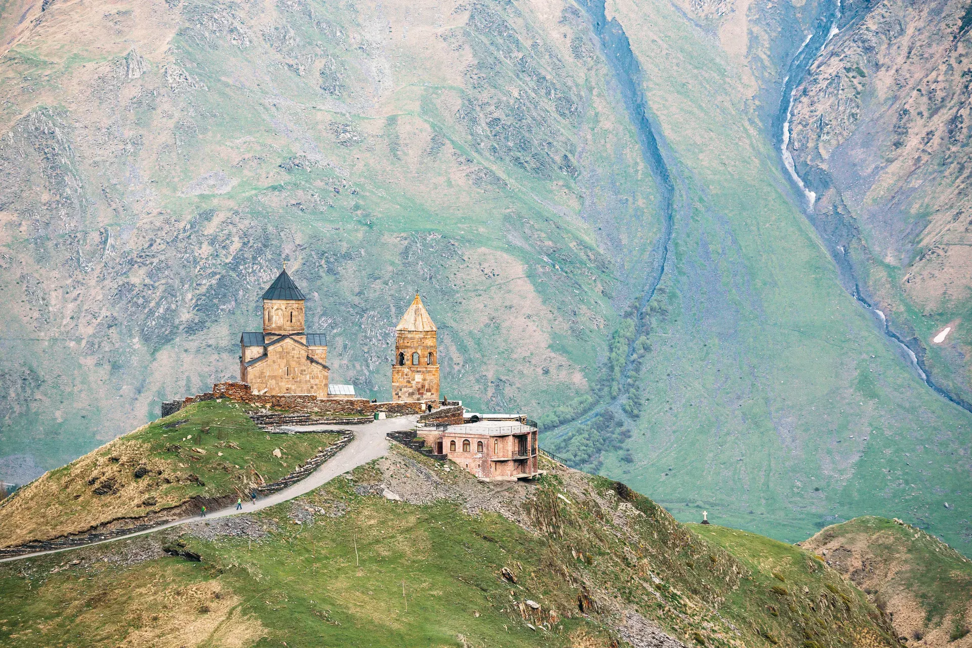
Every Georgia travel article uses this image: a 14th-century church on a hilltop with 5,047-meter Mount Kazbek looming behind it. It's cliché for a reason — the sight genuinely stops you in your tracks.
The hike itself is straightforward. From Stepantsminda (still called Kazbegi by everyone), you follow a well-worn path uphill for about 3 kilometers, gaining roughly 500 meters of elevation. On a clear day, it takes 60–90 minutes up. The trail is obvious and doesn't require navigation skills.
Here's what the Instagram posts don't tell you: the first half of the "trail" follows a dusty 4x4 road, and in summer there's a steady stream of jeeps hauling tourists to the top. Walk to the side, eat the dust, and know that the views from the church are worth it. On busy days, the church compound is crowded. Go early morning or late afternoon.
Extend the Hike
Don't just do the church and head back. Continue beyond Gergeti toward the Gergeti glacier viewpoint — an additional 2–3 hours that leaves the crowds behind completely. The trail gets fainter but the views of Kazbek's glaciers are spectacular. This extension turns a tourist walk into a proper hike.
Getting There
Marshrutka from Tbilisi (Didube station) to Stepantsminda, ~3 hours, 20 GEL. Or shared taxi for ~40 GEL.
Best Time
June to October. July–August for the clearest Kazbek views. September for fall colors and fewer crowds.
2. Truso Valley — Mineral Springs and Ghost Villages
Truso Valley is what happens when you take a wrong turn on the Georgian Military Highway and end up somewhere extraordinary. The valley runs parallel to the border with Russia's North Ossetia, following the Terek River through a surreal landscape of travertine formations, mineral springs that bubble up orange and white, and abandoned Ossetian villages.
The standard hike follows the valley floor from the trailhead (accessible by 4x4 or a 30-minute walk from the road) to the end of the valley and back. It's relatively flat, making it one of the more accessible longer hikes in the Kazbegi area. The trail is clear — you basically follow the river upstream.
What makes Truso special isn't difficulty — it's the otherworldly scenery. The mineral deposits create alien-looking formations along the riverbanks. Abandoned stone towers and houses dot the valley, remnants of the Ossetian communities that left after the 2008 war. There's a functioning monastery near the trailhead, and a couple of the springs are warm enough to dip your feet in.
Border Zone Notice
Truso Valley is close to the Russian border. You don't need a special permit for the standard trail, but don't wander off the main path toward the border. Georgian border guards patrol the area and will check your passport. Keep it on you.
3. Juta to Roshka via Chaukhi Pass — The Dolomites of Georgia
The Chaukhi massif is a cluster of jagged rock spires that look like they were teleported from the Italian Dolomites. The trek from Juta village (2,200m) over Chaukhi Pass (3,338m) and down to Roshka village is widely considered one of the best one-to-two-day hikes in the country.
From Juta, you hike up through alpine meadows with the Chaukhi towers growing larger ahead of you. The approach to the pass is steep and rocky, with some scrambling near the top. The pass itself is a narrow gap between cliff walls with views that make the effort feel insignificant. The descent to Roshka is long and knee-punishing but drops you into one of Khevsureti's remote villages.
The catch: Roshka is hard to get out of. There's no regular transport. You'll need to arrange a pickup in advance, hitchhike (possible but not guaranteed), or continue walking to the Shatili road. Plan this before you go over the pass, not after.
Difficulty Note
The pass at 3,338m involves loose scree and steep sections. Not technical, but you need basic mountain fitness and proper footwear. Snow can linger on the pass into early July.
Camping
Most hikers camp near Abudelauri Lakes (about halfway). Flat ground, water nearby, stunning setting. Juta has basic guesthouses if you want to start fresh.
4. Mestia to Ushguli — The Classic Georgian Trek
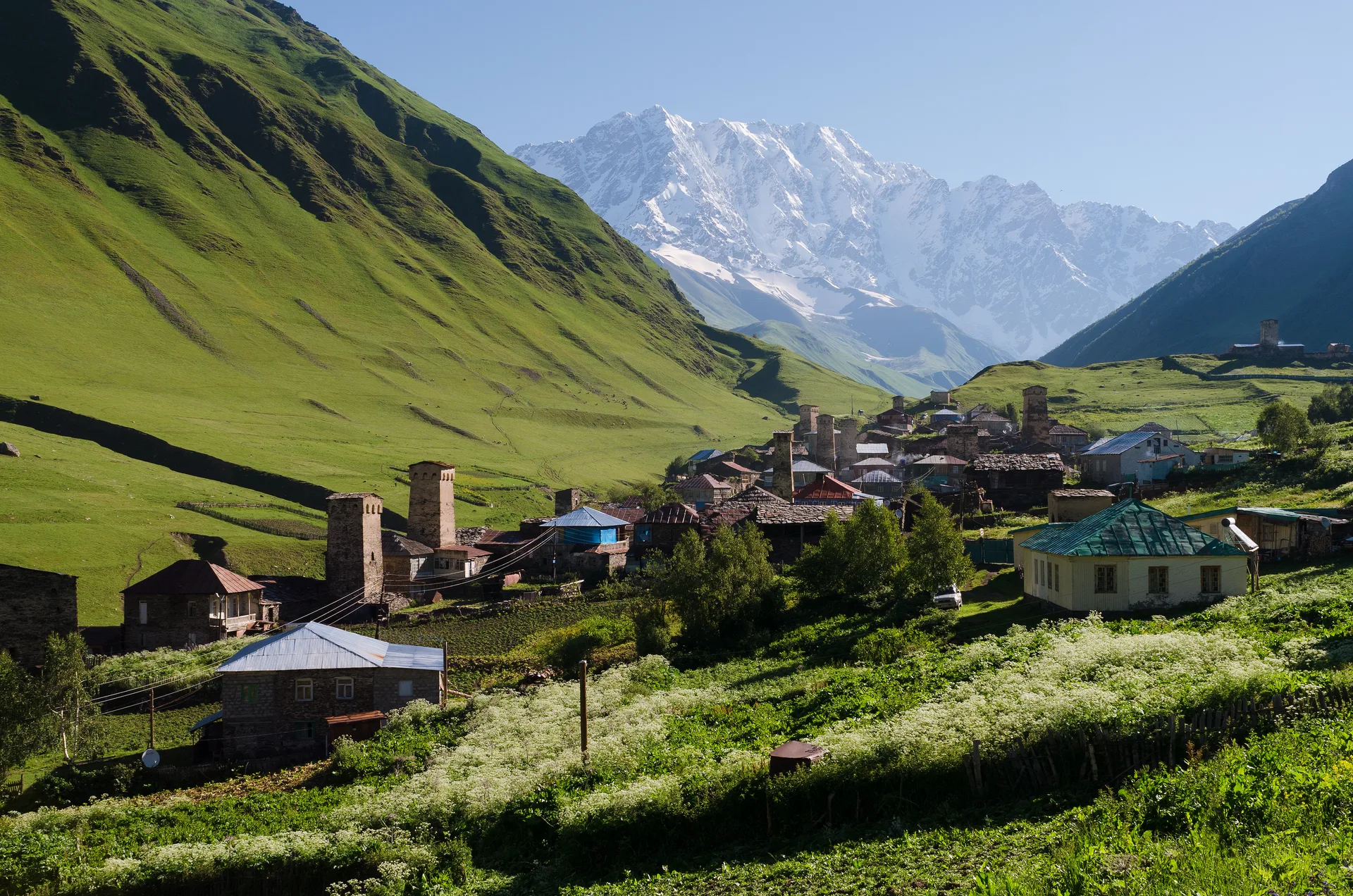
If you can only do one multi-day trek in Georgia, this is probably it. The four-day route from Mestia to Ushguli traverses the heart of Svaneti, passing through traditional villages with their iconic medieval towers, crossing flower-filled meadows, and ending at Europe's highest permanently inhabited settlement.
The standard itinerary breaks into four days: Mestia to Zhabeshi (18 km), Zhabeshi to Adishi (14 km), Adishi to Iprali (16 km), and Iprali to Ushguli (10 km). Each day ends in a village with guesthouses, so you can do this trek with just a daypack if you book ahead. Meals included at most guesthouses — expect heavy, carb-loaded Svan food.
Day three has the crux: the Adishi river crossing. There's no bridge. In early summer when snowmelt is high, the river can be thigh-deep and fast. Locals sometimes operate a horse-crossing service for a few lari. By August, the water is usually manageable. If the water is high and you're not confident, don't force it. Wait for a local with horses or go back.
Skip the Jeep Road
A 4x4 road now connects Mestia to Ushguli, and some hikers accidentally end up walking parts of it. The hiking trail is separate from the road for most sections — look for marked footpaths that cut through meadows and forests. The road is dusty and dull compared to the actual trail.
Mestia–Ushguli Budget (Per Person)
5. Koruldi Lakes — The Best Day Hike from Mestia
If you're in Mestia and have one day for hiking, do Koruldi Lakes. The trail climbs steeply from town through forest and then opens into alpine meadows with views of Ushba, Tetnuldi, and the entire Svaneti range spread before you. The "lakes" are small alpine pools at about 2,740m — pretty, but the real payoff is the panorama.
The trail is well-marked and starts from the cross above Mestia. It's relentless uphill for the first two hours, then flattens out. Total elevation gain is about 1,200 meters. Go early — clouds typically build in the afternoon and obscure the peaks. The descent is fast on the same path.
A shortcut: 4x4 taxis can drive you partway up a dirt road, cutting the hike to about 4 hours round trip. Worth it if your knees disagree with 1,200m of descent.
6. Tobavarchkhili (Silver Lake) — Georgia's Hidden Gem
Tobavarchkhili translates to "Silver Lake," and when you see it — a massive alpine lake at 2,650m surrounded by peaks, with water that shifts between silver and turquoise — the name makes sense. This is one of the most beautiful spots in Georgia that most visitors never hear about.
The trek starts near the town of Khoni in Samegrelo (western Georgia) and takes 3–4 days round trip. The trail passes through dense forest, crosses several passes, and involves significant elevation changes. Navigation can be tricky in places — this isn't a tourist trail with signposts. Download GPX tracks before you go.
The reward is solitude and scenery that rivals anything in Svaneti. Tobavarchkhili is much less visited because it's harder to reach and less well-known. If you've done the popular routes and want something more adventurous, this is it.
Not for Beginners
Tobavarchkhili is remote and has no guesthouses or services along the route. You need full camping gear, navigation skills, and experience with multi-day wilderness treks. Weather changes fast. River crossings can be dangerous after rain. Go with a guide if it's your first time in Georgia's backcountry.
7. Omalo to Shatili — The Ultimate Georgia Trek
This is the big one. The five-day traverse from Omalo in Tusheti to Shatili in Khevsureti crosses the Atsunta Pass (3,431m) and links two of Georgia's most remote and dramatic mountain regions. Many experienced hikers rank it among the best treks in the entire Caucasus.
Tusheti is accessible only by road from June to October (via the infamous Abano Pass, the most dangerous road in Georgia). The trek itself follows ancient trade routes between mountain communities. You start in Tusheti's stone tower villages, climb through alpine meadows, cross the Atsunta Pass, and descend into the equally medieval Khevsureti with its fortified villages and defensive towers.
The Atsunta Pass day is long and demanding. You gain about 1,200m from the last camp, and snow can persist on the pass into July. The descent into Khevsureti is steep and rocky. On both sides of the pass, you're in genuine wilderness — no phone signal, no buildings, no people. Pack everything you need.
Tusheti Side
Start in Omalo, trek through Dartlo and the Pirikiti Alazani valley. Stone towers, green meadows, shepherd camps. Guesthouses in villages for first 1–2 nights.
Khevsureti Side
Descend to Ardoti and on to Shatili. Khevsureti feels more wild and less visited than Tusheti. Shatili's fortified village complex is unforgettable.
8. Lagodekhi Black Rock Lake — Forest, Wildlife, Solitude
Lagodekhi Protected Areas, in Georgia's far northeast corner near the Azerbaijani border, offers something different from the Caucasus high-mountain treks. This is ancient forest — towering beech and hornbeam canopy, clear rivers, and a chance to spot chamois, deer, and (if you're very lucky and slightly nervous) brown bear signs.
The Black Rock Lake trek is the park's marquee route. It's a 28-kilometer round trip to a glacial lake at 2,800m, set among dark volcanic rock. Most hikers do it in two days with a night camping near the lake. The trail is well-maintained by national park standards — marked, with a few shelters along the way.
The first day is mostly forest walking, crossing the river several times on simple bridges. The second half climbs steeply above the treeline. The lake itself is moody and beautiful — dark water surrounded by black rock walls, very different from the green valleys you walked through to get here.
Registration Required
You must register at the Lagodekhi visitor center before hiking. It's free, but they limit the number of hikers on trails and want to know your planned route. Bring your passport. The center also rents basic camping gear if needed.
9. Abudelauri Lakes — Three Colors, One Hike
Three alpine lakes — one blue, one green, one white — tucked beneath the Chaukhi massif near Juta. The Abudelauri Lakes are often combined with the Chaukhi Pass trek (hike #3 above), but they work perfectly as a standalone day hike or overnight from Juta.
The trail from Juta to the lakes is about 7 km one way, crossing a 3,000m pass with views of the Chaukhi towers. The lakes get their colors from different mineral compositions in the rock. The green lake is the most photogenic; the white lake is the most remote. Most hikers camp near the green lake.
This is a solid intermediate hike — not technically difficult, but the elevation and distance require decent fitness. The trail is mostly clear, though the section between the second and third lakes can be vague. Start early for the best light on the lakes.
10. Borjomi-Kharagauli National Park Traverse
Borjomi-Kharagauli is Georgia's most developed national park in terms of hiking infrastructure. It has marked trails, staffed shelters with bunk beds and fireplaces, and a proper permit system. If you want multi-day hiking with some creature comforts and lower risk, this is your best bet.
The park sits in central Georgia, an easy marshrutka ride from either Borjomi (famous for its mineral water) or Kutaisi. The most popular multi-day route is the Nikoloz Trail — a three-day traverse across the park, staying at mountain shelters each night. The terrain is mostly forested with meadow sections, topping out at about 2,600m.
It's less dramatic than Svaneti or Kazbegi. No glaciers, no 5,000m peaks on the horizon. But the forests are magnificent — old-growth beech and conifer stands — and the park's infrastructure means you don't need to carry a tent. A good option for hikers who want to ease into Georgian trekking.
| Trail Name | Days | Distance | Best For |
|---|---|---|---|
| Nikoloz Trail | 3 days | 54 km | Full traverse, shelter-to-shelter |
| Likani Trail | 1 day | 13 km | Forest walk, viewpoints |
| Panorama Trail | 2 days | 36 km | Ridge walking, meadows |
11. Kazbek Base Camp — As Close to 5,000m as You Can Walk
You don't need to be a mountaineer to reach the Kazbek meteorological station (Betlemi Hut) at 3,653m. The hike from Stepantsminda goes past Gergeti Trinity Church and continues up the moraine alongside the Gergeti glacier. It's a long, demanding day — about 18 km round trip with 2,100m of total elevation gain — but it's all hiking, no climbing equipment needed.
The trail above the church becomes rougher and less defined. You'll cross glacier moraine (loose rock), and the final approach involves some exposed sections where a slip would be bad. This isn't a casual day hike — bring layers, food, water, and start before dawn. Weather at 3,600m can turn ugly fast.
From the base camp, you're looking directly at Kazbek's summit glacier. On a clear day, you can see climbers ascending toward the peak. It's as close to a 5,000m summit as most people will ever stand, and it feels like it.
12. Tusheti Panorama Circuit — Medieval Georgia
Tusheti is Georgia's most remote inhabited region. Getting there is an adventure in itself — the road over Abano Pass (2,826m) is a narrow, unpaved cliff road with no guardrails and vertiginous drops. Once you arrive, you're in a world of stone towers, eagle country, and communities that lived essentially independently for centuries.
The Omalo circuit is a 2–3 day loop starting from the regional "capital" (Omalo, population maybe 50 in summer). You visit Dartlo, Diklo, and Shenako — all tiny villages with defensive towers, traditional architecture, and guesthouses run by families who've been here for generations. The hiking between villages follows ridgelines and river valleys, with constant views of the Greater Caucasus.
Tusheti's season is short — roughly July to September. Outside those months, the road closes and the villages empty. This compressed window means you need to plan ahead. Guesthouses fill up in August, and transport over Abano Pass can be unpredictable.
Getting to Tusheti
Shared 4x4s leave from Alvani (Kakheti) for Omalo — about 4 hours over Abano Pass, 80–100 GEL per person. The road is genuinely terrifying if you're not used to mountain driving. No bus service. Book your seat the day before; vehicles leave early morning.
When to Hike: Season by Season
| Month | Conditions | Best For |
|---|---|---|
| June | Snow melting, rivers high, some passes still closed | Lower elevation hikes, Borjomi-Kharagauli, Lagodekhi |
| July | Most passes open, wildflowers peak, warmest temps | Everything — best all-around hiking month |
| August | Dry, warm, busiest month, river crossings easier | Multi-day treks, Tusheti, Chaukhi Pass |
| September | Cooler, fall colors starting, fewer crowds | Svaneti, Kazbegi — best photography month |
| October | Cold at altitude, first snow on passes, short days | Lower elevation hikes only — Tusheti road closes |
Practical Tips for Hiking in Georgia
Navigation
Marked trails are the exception, not the rule. Even the popular routes have sections where the path fades into meadow grass or splits into cattle tracks. Download GPX tracks from caucasus-trekking.com (the single best resource for Georgian trail data) or use the Organic Maps / Maps.me apps, which have decent Georgian trail coverage.
Do not rely solely on Google Maps for hiking in Georgia. It's fine for road navigation but often shows trails that don't exist or misses trails that do.
Water
Georgia's mountain streams are generally safe to drink from above the treeline, where there's no human or livestock activity upstream. Below the treeline and near villages, treat or filter. A lightweight filter like a Sawyer Squeeze is the easiest solution. You'll find water frequently on most routes — dehydration is less of a concern here than in dryer mountain ranges.
Accommodation on the Trail
On popular routes (Mestia–Ushguli, Tusheti villages), family guesthouses offer dinner, bed, and breakfast for 60–100 GEL per person. The food is heavy and homemade — think boiled potatoes, cheese, bread, meat stew, and unlimited chacha (grape brandy) if you're not careful.
On wilder routes, you'll need a tent. Wild camping is legal and common throughout Georgia's mountains. Standard courtesy applies: camp away from water sources, pack out all trash, and if you're near a village, ask before pitching.
Gear
Bring proper hiking boots (ankle support matters on rocky Georgian trails), rain gear (storms come fast), layers for altitude, and sun protection. A trekking pole makes the steep descents much more bearable. If camping, a 3-season tent and sleeping bag rated to at least 0°C will cover most summer conditions.
You can buy basic hiking supplies in Tbilisi at shops near Marjanishvili. For serious gear, the selection is limited — bring anything specialized from home.
Shepherd Dogs
Georgian shepherds use large livestock guardian dogs (Caucasian Shepherds and Nagazi) to protect flocks from wolves and bears. These dogs can be aggressive toward hikers who get too close to the flock. If you see sheep with dogs: don't approach, don't run, give a wide berth, and keep your own dog on a leash (or better, leave it at home). Most encounters are fine if you stay calm and keep your distance.
Guides and Safety
For the easy hikes (Gergeti, Koruldi Lakes, Truso), you don't need a guide. For harder routes (Tobavarchkhili, Omalo–Shatili), a local guide is strongly recommended unless you have significant backcountry experience. Mountain rescue in Georgia exists but response times can be very long. Cell coverage is spotty to nonexistent on most trails above villages.
Guided treks can be arranged through guesthouses in Mestia, Stepantsminda, or Omalo. Budget around 100–150 GEL per day for a local guide, plus their meals. It's money well spent on remote routes.
Understanding Difficulty Ratings
Easy
Well-defined trail, moderate elevation gain (<500m), doable in half a day. No navigation skills needed. Examples: Gergeti Church, short Borjomi trails.
Moderate
Full day or multi-day with guesthouses. Elevation gain 500–1,200m. Trail mostly clear. Good fitness required. Examples: Mestia–Ushguli, Koruldi Lakes.
Challenging
High passes (3,000m+), steep terrain, possible scrambling. Need navigation skills and mountain experience. Examples: Chaukhi Pass, Kazbek Base Camp.
Hard
Multi-day wilderness with camping required. Remote, no services, river crossings. Full backcountry experience essential. Examples: Omalo–Shatili, Tobavarchkhili.
Resources and Maps
Georgia's hiking infrastructure is still developing, but these resources will get you started:
- Caucasus Trekking — The most comprehensive resource for Georgia hiking trails. Detailed descriptions, GPX files, photos, and honest difficulty assessments. Run by a hiker who's walked every trail himself.
- Organic Maps / Maps.me — Free offline map apps with good Georgian trail coverage. Download the Georgia map before you leave Tbilisi.
- Geoland Maps — Paper topographic maps available at bookshops in Tbilisi. Useful as backup and for planning.
- Trails.ge — Government-backed trail database. Hit or miss, but has some useful route descriptions.
- National park visitor centers — In Borjomi, Lagodekhi, and Mestia. Free trail info, registration, and sometimes gear rental.
Written by The Georgian Guide Team
Based in Tbilisi with years of hiking the Caucasus. We've walked every trail on this list — some of them multiple times — and our boots have the scars to prove it.
Last updated: February 2026.
Related Articles
Svaneti Travel Guide
Everything you need for Georgia's wildest mountain region.
Georgian Military Highway Guide
The epic road through the Caucasus — gateway to Kazbegi and Gergeti.
Best Time to Visit Georgia
Month-by-month breakdown for planning your trip.
Getting Around Georgia
Transport options from marshrutkas to rental cars.