The Mestia to Ushguli trek is the most famous multi-day hike in Georgia, and for good reason. Four days through the heart of Svaneti, passing medieval tower villages, crossing glacial rivers, climbing over passes with views that make the Alps look tame. It's tough, sometimes miserable, and absolutely worth every blister. Here's everything you need to actually do it.
Trek Overview
Let's get the basics straight. This is not a technical mountaineering route. You don't need ropes, crampons, or climbing experience. What you do need is reasonable fitness, decent shoes, and the willingness to push through days where the trail disappears, the weather turns foul, and the only way forward is a glacial river crossing that looks deeply questionable.
The classic route runs south from Mestia to Ushguli, following the Mulkhura and Enguri river valleys with two significant passes in between. Most people do it in four days, though you can add a fifth if you want to take it slower or add detours to glacier viewpoints.
| Day | Route | Distance | Elevation Gain | Time |
|---|---|---|---|---|
| 1 | Mestia → Zhabeshi | 18 km | ~700m | 5–6 hours |
| 2 | Zhabeshi → Adishi | 12 km | ~800m | 4–5 hours |
| 3 | Adishi → Iprali (via Chkhutnieri Pass) | 18 km | ~1,200m | 7–9 hours |
| 4 | Iprali → Ushguli | 10 km | ~500m | 3–4 hours |
When to Go
The trekking season runs from mid-June to mid-October, with a sweet spot in July and early September. Here's the honest breakdown:
Mid-June to early July: Snow may still block the passes, especially Chkhutnieri. The Adishi river crossing is at its worst — snowmelt turns it into a serious, thigh-deep torrent. Wildflowers are incredible though, and the mountains are at their most dramatic with snow still clinging to the peaks. You'll have the trail mostly to yourself.
July to August: Peak season. Passes are clear, river crossings are manageable (still cold, still unpleasant), guesthouses are full. Weather is warmest but afternoon thunderstorms are common — start early. This is when most people go, and it's the safest window.
September: The sweet spot for many. Crowds thin out, the air is crisp, fall colors start appearing at lower elevations. River crossings are at their easiest. The weather can be brilliant — clear skies and cool temperatures. But days are shorter and the weather window is less predictable.
October: Risky. Early snow can close passes with little warning. Guesthouses start closing up. Some years October is gorgeous; other years you'll be turned back at Chkhutnieri in a whiteout. Only for experienced hikers who are comfortable changing plans.
Weather Reality Check
Svaneti weather changes fast. It can be blazing sunshine at breakfast and sleeting by lunch. Pack for four seasons regardless of when you go. The one certainty: if the forecast says sun all week, it's wrong.
Day 1: Mestia to Zhabeshi (18 km, 5–6 hours)
The first day is the gentlest, which is a kindness because you're still adjusting to your pack weight and the altitude. From Mestia (1,500m), you head southeast along a mix of dirt roads and trails, gradually climbing along the Mulkhura Valley.
The trailhead starts just past Dissident Café, across the bridge on the east side of town. You'll see yellow trail markers pointing toward Zhabeshi — follow them. The first hour is the least scenic bit of the entire trek: dusty village roads, some construction, a gradual uphill that's more boring than challenging.
Stick with it. Around 45 minutes in, the road narrows to a proper trail and the views open up. To your left, if clouds cooperate, you'll get your first look at Mount Ushba — a double-peaked monster that's considered one of the most dangerous climbs in the Caucasus. It's stunning from a safe distance.
The trail winds through alpine meadows thick with wildflowers in summer, dips through patches of forest, and crosses a few small streams. There's one steep section midway that gets your lungs working, but nothing sustained. You'll pass through the tiny settlement of Lakhiri (sometimes marked as Laghami on maps — Svaneti has a naming consistency problem) before descending slightly into Zhabeshi.
Zhabeshi is a tiny village with a handful of family guesthouses. Don't expect Booking.com listings — you ask around, someone points you to a bed, and dinner appears on the table. A bed with dinner and breakfast runs 50–80 GEL per person (about $18–30). The food is hearty Svan cooking: kubdari (meat pies), beans, potatoes, fresh bread, and probably too much chacha (grape brandy) if your host is in a generous mood.
Alternative: Stop at Mulakhi
If 18 km on day one feels like too much, you can split it by stopping in Mulakhi (about 10 km from Mestia). A few guesthouses operate there in summer. This turns the trek into a 5-day affair, which some prefer.
Day 2: Zhabeshi to Adishi (12 km, 4–5 hours)
Shorter day, but more dramatic. From Zhabeshi, the trail climbs steadily through forest and meadow, crossing into a wider valley with the Adishi glacier visible ahead. This is where Svaneti starts to feel truly wild — fewer signs of civilization, bigger mountains, longer sightlines.
The trail is generally well-marked but there are a few spots where you'll need to watch for faded yellow markers on rocks. A GPS track or the Maps.me app with Georgia offline maps is strongly recommended. The path crosses several small streams — no problem in normal conditions, though after heavy rain they can be ankle-deep and slippery.
About two hours in, you'll reach the high point of the day — a broad saddle with panoramic views down the Adishi valley. On a clear day, this is where you stop, sit on a rock, and question why you spent so many years not doing this. The Adishi glacier fills the valley head, massive and blue-white, with the 4,000m+ peaks of the Svaneti range forming a wall behind it.
The descent to Adishi village is straightforward if a bit steep in places. Adishi itself is one of the most atmospheric stops on the trek — a cluster of medieval stone houses and Svan towers at 2,040m, with maybe a dozen permanent residents. In summer, a few families run guesthouses. Same deal as Zhabeshi: show up, ask around, dinner appears.
Adishi has no shops, no ATM, no phone signal (sometimes). There's a small café that operates sporadically in summer. Bring what you need. The evenings here are magical — complete silence except for cowbells and the distant rumble of glacial melt. If you have time, walk up toward the glacier viewpoint above the village (about 30 minutes each way) for one of the best sunset views on the entire trek.
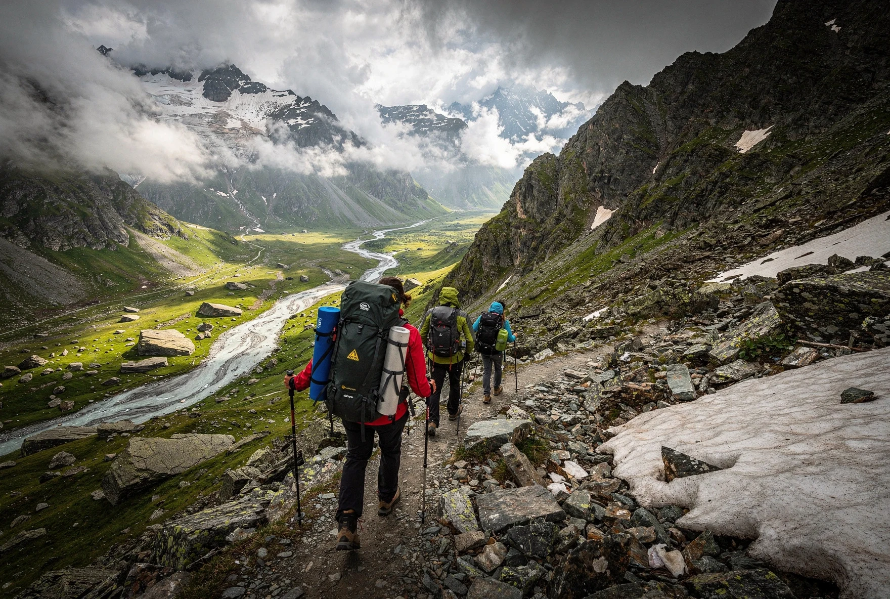
Day 3: Adishi to Iprali via Chkhutnieri Pass (18 km, 7–9 hours)
This is the big one. Day 3 is the crux of the entire trek — the longest day, the highest point, and the most challenging terrain. If there's a day that breaks people, it's this one.
The day starts with the Adishi river crossing, which deserves its own section because it's the single most-discussed obstacle on the route.
The Adishi River Crossing
About 30 minutes out of Adishi, you reach the Adishi River — a braided glacial stream that you need to ford. There's no bridge. The depth and difficulty depend entirely on the time of year and recent weather.
In July–August: Usually knee-deep, manageable but cold. The water is glacial melt — expect it to be shockingly cold even on hot days. Use trekking poles for balance, unbuckle your hip belt (so you can ditch your pack if you fall), and wear sandals or old sneakers for the crossing. Don't go barefoot — the riverbed is rocky and the cold numbs your feet so you can't feel the sharp ones.
In June (early season): Can be thigh-deep and genuinely dangerous. The volume of snowmelt is at its peak. If the water is above your knees and fast-flowing, seriously consider whether to attempt it. People have been swept off their feet here. In high water, some locals offer horse crossings for about 20–30 GEL.
In September: Usually the easiest — lower water, less current. Still cold.
River Crossing Safety
Cross early in the morning when water levels are lowest (glaciers melt more in afternoon heat). Face upstream, lean into your poles, move one foot at a time. If the water is above mid-thigh and fast, turn around — the pass will be there tomorrow. A bridge may be in place by 2026; check locally in Mestia before starting.
Chkhutnieri Pass (2,722m)
After the river, the real climbing begins. The trail ascends steadily through alpine meadows before reaching a series of steep switchbacks up to Chkhutnieri Pass at 2,722m. The climb from the river to the pass is about 700m of elevation gain over roughly 4 km — it's relentless but not technical.
The pass itself is a broad, rocky saddle with cairns marking the high point. The view from the top is the single best moment of the entire trek — you can see back toward Adishi and the glacier, forward into the Enguri valley leading to Ushguli, and sideways to peaks in every direction. If the weather is clear, take your time here. Eat your snacks. This is why you're doing this.
The descent from the pass is steep, loose, and hard on the knees. About 800m of descending over rocky trails and scree slopes brings you down to the village of Khalde, from where it's a further 5 km along a relatively flat valley trail to Iprali (sometimes listed as Ipari on maps).
Iprali has a few guesthouses. After 7–9 hours of hiking, you'll be grateful for the food and the bed. Expect to be tired in a way that city life never produces — a deep, honest, physical exhaustion that makes everything taste better and sleep come instantly.
Day 4: Iprali to Ushguli (10 km, 3–4 hours)
The victory lap. Day 4 is short and relatively easy — a gentle valley walk along the Enguri River to Ushguli. The terrain is mostly flat or gently rolling, following a mix of trails and dirt roads. You'll pass through the villages of Davberi and Bogreshi along the way.
This is a good day to slow down and absorb the landscape. The Enguri valley is wide and green, framed by mountains on both sides, with Svan towers punctuating every village you pass through. The trail is clear and well-traveled.
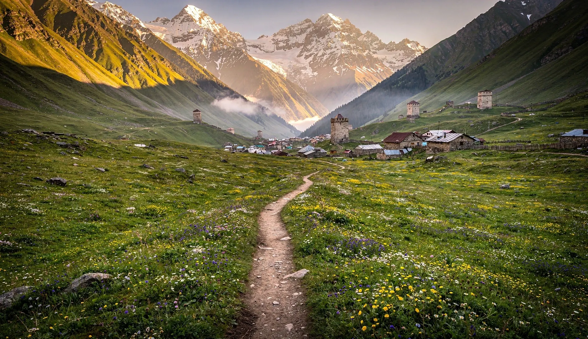
Ushguli is actually a cluster of five small hamlets — Murqmeli, Chazhashi, Chvibiani, Zhibiani, and Chubliani — at roughly 2,100m elevation. Chazhashi, with its dense cluster of towers, is the most photographed. The whole area is UNESCO World Heritage listed, and it feels like stepping back several centuries.
You'll likely arrive by lunchtime, which gives you the afternoon to explore. Walk up to the Lamaria Church on the hill above Chazhashi for the iconic view of the towers with Mount Shkhara (5,201m) behind them. Visit the small ethnographic museum. Eat kubdari. Sit in a field and stare at mountains. You've earned it.
Getting to Mestia (and Back from Ushguli)
Reaching Mestia
| From | Option | Cost | Time |
|---|---|---|---|
| Tbilisi | Train to Zugdidi + marshrutka | ~56 GEL | 10–11 hours total |
| Tbilisi | Direct marshrutka (7:00 AM) | 40 GEL | 9–10 hours |
| Tbilisi | Shared taxi (4 passengers) | ~140 GEL pp | 7–8 hours |
| Tbilisi | VanillaSky flight (Natakhtari) | 90 GEL | 1 hour (4 flights/week) |
| Kutaisi | Direct marshrutka (9:00 AM) | 40 GEL | 4–5 hours |
| Zugdidi | Marshrutka (multiple daily) | 40 GEL | 3.5–4 hours |
| Batumi | Budget Georgia transfer | 80 GEL | 7–8 hours (via Zugdidi) |
The Flight Option
VanillaSky operates small prop planes from Natakhtari (near Tbilisi) to Mestia. At 90 GEL it's a bargain, and the views of the Caucasus from above are extraordinary. The catch: flights cancel frequently due to weather, and they book up weeks in advance in summer. Have a backup plan.
Getting Back from Ushguli
Ushguli is connected to Mestia by a rough mountain road (about 4–5 hours by 4x4). In summer, shared jeeps run daily for about 40–50 GEL per person. Your guesthouse in Ushguli can arrange this. From Mestia, you reverse whatever route brought you in.
Alternatively, some hikers arrange a one-way jeep transfer for luggage from Mestia to Ushguli before starting the trek, so they can hike with lighter packs and pick up their main bag at the end. Smart if you're not into ultralight trekking.
What to Pack
🥾 Essential Gear
Sturdy hiking boots (broken in!), trekking poles (essential for river crossings), rain jacket and pants, warm fleece or down jacket, sun hat and sunglasses, headlamp, 2L+ water capacity, basic first aid kit
🛏️ Guesthouse Trek
No tent or cooking gear needed if staying in guesthouses. Bring a sleeping bag liner (hygiene), earplugs (cows start early), sandals for river crossing, quick-dry towel, toilet paper, phone charger and power bank
⛺ Camping Option
Tent, sleeping bag (comfort 0°C+), sleeping pad, stove and fuel, 4 days of food. Adds 5–8 kg to your pack but gives total freedom. Wild camping is tolerated everywhere along the route.
📱 Navigation
Download Maps.me or Organic Maps with Georgia offline before you go. Download a GPX track of the route (widely available online). Phone signal is absent for most of the trek. Carry a power bank.
Budget Breakdown
4-Day Trek Budget (Guesthouse Route)
That's remarkably cheap for a 4-day multi-day trek. You'd spend more on a single night in a Swiss mountain hut. The guesthouse meals are generous — big breakfasts and dinners — so you only need to carry trail snacks and water for the hiking hours. Bring cash; none of these villages have card payment.
Guesthouses and Accommodation
There are no hotels on this route. Accommodation is in family-run guesthouses — usually a spare bedroom in someone's home, with a shared bathroom (sometimes outside), home-cooked meals, and the kind of hospitality that makes you question the entire concept of hotels.
| Village | Options | Price (half-board) | Notes |
|---|---|---|---|
| Zhabeshi | 3–5 guesthouses | 50–80 GEL | Ask in village; most don't have online presence |
| Adishi | 3–4 guesthouses | 60–80 GEL | More remote; book ahead if possible |
| Iprali | 2–4 guesthouses | 50–80 GEL | Smallest selection; arrive early in peak season |
| Ushguli | 10+ guesthouses | 60–100 GEL | Most options; some bookable on Booking.com |
Booking Strategy
In July and August, guesthouses can fill up. Your guesthouse in Mestia can usually call ahead to book your stops. Outside peak season, just show up — there's always a bed. Half-board means dinner and breakfast, which is what you want. Lunch is whatever you carry in your pack.
How Hard Is It, Really?
This is the question everyone asks, and the answer depends on what you're comparing it to.
If you're a regular hiker who does day hikes on weekends and has done at least one multi-day trek before — you'll be fine. Day 3 will be tough but manageable. You'll be tired but not broken.
If you're reasonably fit but not a hiker — you can do it, but train beforehand. Walk 15 km with a loaded pack at least a few times before you arrive. The uphills are more about endurance than steepness, and the descents are harder on your body than you'd expect.
If you're a couch-to-Caucasus type — consider the 5-day version (add a stop at Mulakhi). Give yourself rest time. It's still doable, but don't underestimate cumulative fatigue. By day 3 your knees and feet are already tired from days 1 and 2.
The terrain itself is not technical. No scrambling, no via ferrata, no exposed ridges. The challenges are: sustained distance, elevation gain/loss, unpredictable weather, the river crossing, and rough trail surfaces (think rocky paths, muddy sections, and the occasional stretch where the "trail" is really just a suggestion).
Guided vs. Self-Guided
Self-Guided
The majority of hikers do this trek independently. The route is generally well-marked with yellow blazes, though some sections are ambiguous. With a GPS track on your phone and basic navigation sense, you'll manage. The main risk is weather and the river crossing.
With a Guide
A local guide costs 100–150 GEL per day ($35–55). Worth it if: it's your first multi-day trek, you're going early/late season when weather is unpredictable, or you want the cultural context. Guides know the river crossing conditions and have local contacts for guesthouses.
Alternative Routes and Detours
The classic Mestia–Ushguli route is the most popular, but there are variations worth knowing about:
Mestia → Koruldi Lakes → Zhabeshi: Instead of the standard Day 1 trail, you can climb up to the Koruldi Lakes (2,740m) above Mestia for a spectacular high-altitude start. This adds significant elevation but the views of Ushba and the surrounding peaks are otherworldly. Only for strong hikers — it turns Day 1 into a proper challenge.
Ushguli → Shkhara Glacier: After arriving in Ushguli, add a day hike to the Shkhara Glacier viewpoint (about 12 km round trip from Ushguli). You walk up the valley toward Georgia's highest peak and can get quite close to the glacier terminus. One of the most dramatic day hikes in the country.
Reverse direction (Ushguli → Mestia): Some people do the trek northbound. The main advantage is tackling the Chkhutnieri Pass and river crossing in the opposite direction, which some find easier. The disadvantage is that the sense of building drama — culminating in Ushguli — is reversed. Most people prefer the southbound classic for good reason.
Practical Tips
| Topic | Detail |
|---|---|
| Water | Mountain streams are generally safe to drink from above the villages. Below villages, purify. Carry at least 2 liters — some stretches have no water for 2+ hours. |
| Phone signal | Patchy at best. Mestia and Ushguli have 3G/4G. In between, expect nothing. Guesthouses sometimes have Wi-Fi (slow). |
| Cash | Bring enough for the entire trek. No ATMs between Mestia and Ushguli. Budget 400–500 GEL to be safe. Small bills preferred. |
| Dogs | Svaneti has livestock guardian dogs that can be intimidating. Walk calmly past, don't run, don't approach. They're protecting sheep, not hunting hikers. Carry a stick if it makes you feel better. |
| Luggage storage | Most guesthouses in Mestia will store your extra bags for free or a small fee while you trek. Ask your host. |
| Start early | Especially on Day 3. Afternoon thunderstorms are common in summer. Being on the pass during a storm is miserable and potentially dangerous. |
Common Mistakes
Not breaking in boots
New boots on a 4-day trek = blisters by lunch on Day 1. Walk at least 50 km in your boots before this trek. Your feet will thank you.
Skipping trekking poles
Poles aren't optional here. The river crossing, the steep descents, the muddy sections — you'll use them constantly. Don't leave them behind to save 400 grams.
Underestimating Day 3
The hardest day comes after two days of hiking when you're already tired. Don't plan anything ambitious for the evening in Iprali — you'll want food and sleep, nothing else.
Not carrying enough cash
There's no ATM between Mestia and Ushguli. If you run short, you can't pay for guesthouses. Bring more than you think you need.
Late starts on Day 3
Mountain weather deteriorates in the afternoon. Starting the river crossing after 10 AM means higher water from glacial melt. Leave Adishi by 7 AM at the latest.
No offline maps
Phone signal disappears quickly outside Mestia. If your navigation depends on data, you'll be lost by Day 1. Download offline maps before you start.
Frequently Asked Questions
Do I need a tent?
No — guesthouses are available at each overnight stop. Camping is an option (and free), but most hikers go the guesthouse route for lighter packs and hot meals.
Is it safe to hike solo?
Yes. Many people solo this trek. You'll likely encounter other hikers, especially in summer. The main risk is the river crossing — having others nearby helps. Tell your guesthouse where you're heading each day.
Can I do it in 3 days?
Technically yes, by combining Days 1 and 2 (Mestia → Adishi, ~30 km). Only for very fit hikers. It makes Day 1 brutal and doesn't save money since you still need 3 nights of guesthouses.
What about altitude sickness?
The highest point is 2,722m (Chkhutnieri Pass). This isn't high enough for serious altitude issues for most people. If you're coming from sea level, you might feel slightly breathless on the climb, but AMS is very unlikely.
Can I do it with kids?
Teenagers who are fit hikers — yes. Younger children — the river crossing and Day 3's length make it a tough call. Consider the Mestia to Koruldi Lakes day hike instead for families.
What if the weather turns bad?
Guesthouses are close enough that you can wait out bad weather. If a serious storm hits on Day 3 while you're on the pass, descend to whichever side is closer. Locals and guesthouse owners will advise. Don't be a hero — flexibility is key.
Written by The Georgian Guide Team
Based in Georgia for over five years, our team has hiked the Mestia to Ushguli route multiple times across different seasons. We know the guesthouses, the river crossings, and the feeling of cresting Chkhutnieri Pass on a clear day.
Last updated: March 2026.
Related Articles
Svaneti Travel Guide
Everything you need to plan a trip to Georgia's most dramatic mountain region.
12 Best Hikes in Georgia
From easy day walks to epic multi-day treks across the Caucasus.
Day Hikes Near Tbilisi
Short treks you can do without leaving the capital region.
Georgia Packing Guide
What to bring for your trip to Georgia, including hiking essentials.