The Juta to Roshka trek over Chaukhi Pass is probably the best one-to-two-day hike in Georgia. You start in a quiet valley two hours north of Tbilisi, climb toward a wall of jagged rock spires that people call the "Georgian Dolomites" (they really do look like that), cross a 3,340-meter pass, descend past three colored alpine lakes, and end up in a remote Khevsureti village where the road only recently arrived. It's challenging, it's beautiful, and it's doable without a guide if you know what you're getting into. Here's everything you need.
Why This Trek Is Special
Georgia has dozens of great hikes. The Mestia to Ushguli trek gets all the press, and the Kazbegi area draws the day-trippers. But the Juta to Roshka crossing hits a sweet spot that's hard to beat: it's short enough to do in a weekend, dramatic enough to feel like a real expedition, and remote enough that you won't be walking in a queue of tourists.
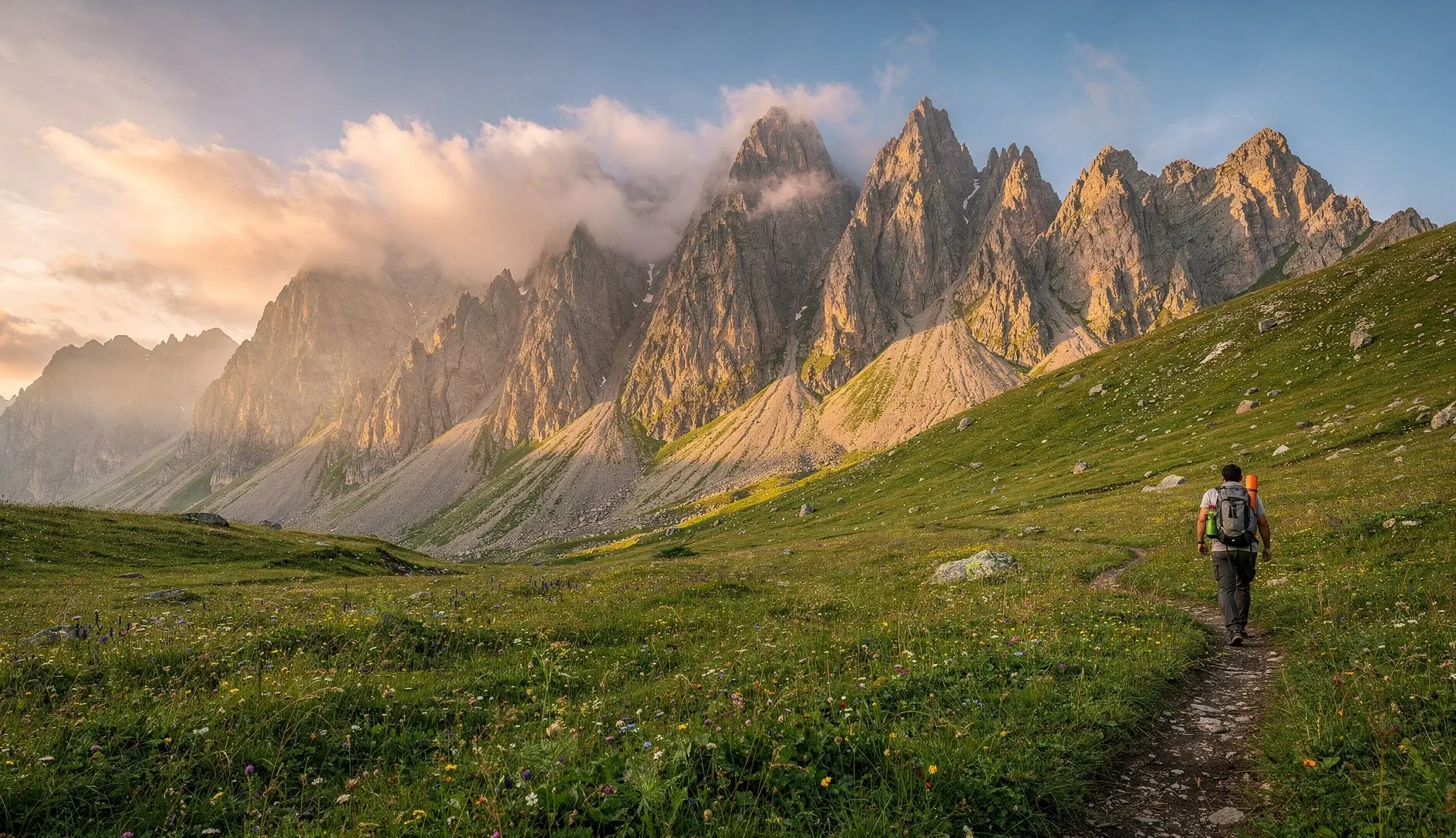
The Chaukhi massif — seven sharp peaks rising to over 3,800 meters — dominates the entire first half of the trek. These aren't soft, rounded mountains. They're violent, vertical towers of volcanic rock that look transplanted from the Dolomites. As you climb toward the pass, the peaks close in around you until you're walking through what feels like a natural cathedral.
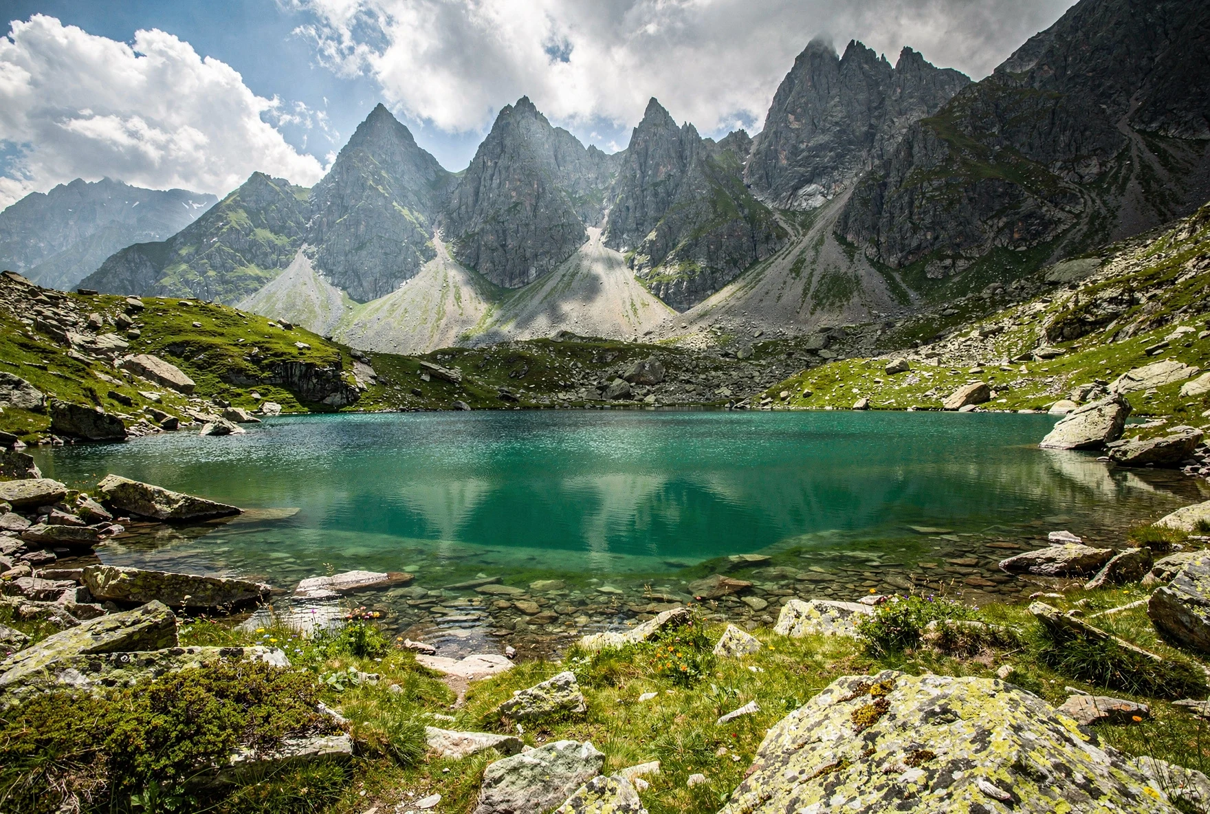
On the other side, everything changes. The descent takes you into Khevsureti — one of Georgia's least-visited highland regions — past the Abudelauri Lakes: three alpine lakes that are genuinely different colors (green, blue, and milky white). Below the lakes, enormous boulders scattered across the valley floor are Ice Age erratics, carried here by glaciers from the Chaukhi massif thousands of years ago. The locals call them "Roshka stones," and they give the lower valley an eerie, otherworldly quality.
Quick Facts
| Detail | Info |
|---|---|
| Trail Type | Point-to-point (Juta → Roshka) |
| Distance | ~18 km (direct) / ~25 km (with all lake detours) |
| Total Ascent | ~1,280 meters |
| Total Descent | ~1,360 meters |
| Highest Point | Chaukhi Pass, 3,340m |
| Difficulty | Moderate-Hard (steep descent with loose rock) |
| Trail Markings | Blue markers (Polish project). Patchy in places. |
| Best Season | Mid-June to mid-October |
| Water on Trail | Streams in valley, none near the pass |
| Cell Service | Spotty in Juta, none on the trail, weak in Roshka |
When to Go
The hiking season runs from mid-June to mid-October, but the window is narrower than you'd think. Snow lingers on Chaukhi Pass well into June most years, and by late October the pass can get its first serious snowfall. July and August are the sweet spot — wildflowers blanket the Juta Valley, the streams are flowing, and the pass is reliably clear.
| Month | Conditions | Verdict |
|---|---|---|
| Mid-June | Snow patches near pass, streams high, wildflowers starting | Possible but check conditions |
| July | Peak wildflowers, clear pass, warm days, afternoon storms | Best month |
| August | Warm, dry, good visibility, busiest period | Excellent |
| September | Cooler, autumn colors, fewer hikers, shorter days | Great, bring warm layers |
| October | Cold nights, possible early snow, unpredictable weather | Risky — experienced hikers only |
Afternoon Storms
Thunderstorms roll in fast in the Caucasus, especially in July and August. Start early — aim to be over the pass by noon. Getting caught in a storm above 3,000 meters on exposed rock is genuinely dangerous. Lightning, hypothermia, slippery shale — all bad.
Getting to Juta
Juta is a tiny village at 2,200 meters, tucked into a side valley about 7 km off the Georgian Military Highway. The turnoff is at Sno village, roughly 10 km south of Stepantsminda (Kazbegi). From Tbilisi, you have a few options.
| Option | Cost | Time | Notes |
|---|---|---|---|
| Marshrutka + taxi | ~25 GEL + 30–40 GEL | 4–5 hours | Marshrutka to Stepantsminda from Didube station, then shared taxi to Juta |
| Private transfer | 200–300 GEL | 3–3.5 hours | Arrange through your guesthouse or Bolt. Door-to-door. |
| Day tour + drop off | 50–80 GEL | ~4 hours | Some Kazbegi tour operators will drop you in Juta. Ask around. |
| Rental car | 80–150 GEL/day | 3 hours | Road to Juta is unpaved but manageable in a sedan. Parking tricky — point-to-point logistics. |
The Point-to-Point Problem
This is a one-way hike — you start in Juta and finish in Roshka. If you drove to Juta, your car is now in the wrong place. Solutions: (1) arrange a pickup from Roshka in advance through your Juta guesthouse, (2) do the Sadzele Pass loop to return to Juta (adds a full day), or (3) hitchhike/taxi from Roshka to Barrisako, then to Stepantsminda. Most hikers arrange transport from Roshka in advance.
The Route: Section by Section
The trail is marked with blue blazes, courtesy of a Polish hiking initiative. The markings are decent but fade in places, especially near the pass. Download an offline map before you go — Maps.me has the trail, and the Caucasus Trekking website offers a solid GPX track.
Section 1: Juta to Upper Valley (2–3 km, ~45 min)
Cross the bridge at the entrance to Juta and turn right onto a small track climbing uphill. Within 15 minutes you'll reach Zeta Camp, a popular camping/guesthouse area. The trail continues past the newer "5 Seasons" guesthouse and along the eastern side of the valley. You'll cross the river at one point — there's no bridge, just a ford. In summer it's ankle-deep; after rain, it can be knee-deep and faster than you'd like.
The valley here is wide and green, with the Chaukhi peaks growing larger ahead of you. Enjoy the flat walking — it won't last.
Section 2: Valley Head to Chaukhi Pass (5–6 km, 3–4 hours)
As the valley bends east, you'll cross several small streams and pass a few campsites of varying cleanliness. There's also a small artificial lake with a pub tent on its bank — a good turnaround point for day-hikers not attempting the pass.
Beyond this, the real climbing begins. The trail turns south and starts gaining altitude steadily over rolling alpine terrain. Then comes the steep section: a relentless zigzag up a hillside that many hikers mistake for the pass itself. It's not. From the top of this false summit, you have another 20 minutes of more gradual walking to the actual Chaukhi Pass at 3,340 meters.
The pass is spectacular. The Chaukhi peaks loom immediately to your west, and the Roshka valley drops away to the south. Take a break here — you've earned it, and you'll want your legs fresh for the descent.
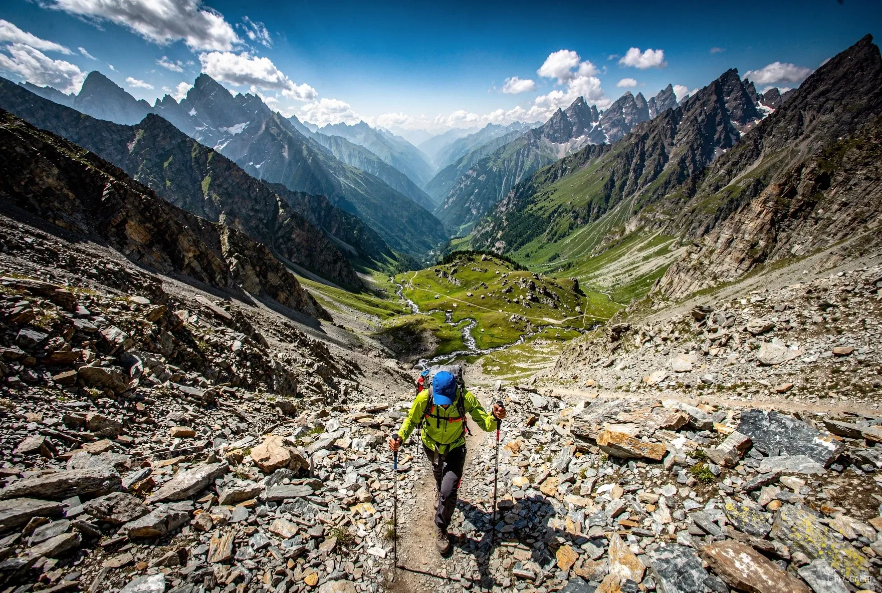
Section 3: Chaukhi Pass to Abudelauri Lakes (3–4 km, 2–2.5 hours)
This is the hardest part of the trek, and it's why you should always hike Juta-to-Roshka rather than the reverse. The descent from the pass is steep, exposed, and covered in loose shale. The old route went straight down — a brutal scree-slide that trashed knees and ankles. The newer trail heads east over a small hill, follows a side ridge, and descends more gradually with switchbacks. It's better, but still demands attention. Trekking poles help enormously here.
Once you reach the valley floor, the trail turns south before swinging left toward the lakes. The Blue Lake comes first, then the Green Lake shortly after — both are easily accessible from the main trail. The White Lake requires a detour of about 30–40 minutes each way, heading further north. It's the most striking of the three, a milky turquoise pool set against a stark rocky backdrop, and worth the extra effort if you have time.
Section 4: Abudelauri Lakes to Roshka (7–8 km, 2–3 hours)
From the lakes, the trail follows the river valley downstream, gradually losing elevation. The Roshka stones — massive glacial erratics scattered across the meadows — give this section a surreal quality. A new Abudelauri mountain hut was completed near the Green Lake in 2024, though its operations remain limited. In late 2025, it was open but unstaffed, functioning as basic shelter.
The lower valley has an ugly road under construction heading toward Arkhoti. It's functional but muddy in places — consider cutting north around the worst sections. The final stretch into Roshka village takes longer than you'd expect: another 2–3 hours of steady walking along the road.
One Day or Two?
This is the big question everyone asks, and the answer depends on your fitness level and priorities.
One Day (7–10 hours)
Doable if you're fit, start by 7 AM, and skip the White Lake. You'll need to move with purpose. No lingering at the pass, no long lunch. You'll arrive in Roshka tired but satisfied. Best for experienced hikers who've done similar distances at altitude.
Two Days (recommended)
Camp at Abudelauri Lakes. This gives you time to explore all three lakes, watch the sunset over the valley, and enjoy the morning light before the final descent to Roshka. You'll need a tent, sleeping bag, and food — there are no services at the lakes.
The Sadzele Loop Alternative
If you have two days and a tent, consider the loop: Juta → Chaukhi Pass → Abudelauri Lakes (camp) → Sadzele Pass → back to Juta. This avoids the point-to-point transport problem entirely. The Sadzele Pass section is less dramatic but still beautiful, and you end up back where you started. The loop is about 30 km total.
Where to Stay
| Location | Option | Cost (2026) | Notes |
|---|---|---|---|
| Juta | Camping Zeta | 50 GEL (with breakfast) | Mountain-hut vibe, good food, card payments. Popular and reliable. |
| Juta | 5 Seasons Guesthouse | 80–120 GEL | Newer, more upscale. Heated rooms, better beds. |
| Juta | Wild camping | Free | Plenty of flat ground in the valley. Bring your own gear. |
| Trail | Abudelauri Lakes camping | Free | Flat grassy areas near the lakes. Water from streams. No facilities. |
| Trail | Abudelauri Hut (new) | TBD | Opened 2024. Basic shelter, potentially staffed in peak season. Check locally. |
| Roshka | Village guesthouses | 50–60 GEL (half board) | Basic but warm. Home-cooked meals included. Cash only. |
What to Bring
Essential for Everyone
Sturdy hiking boots (ankle support critical for the descent), trekking poles, 2+ liters of water, rain jacket, warm fleece or puffy jacket, sun protection, offline map (Maps.me or downloaded GPX), headlamp, first aid kit, snacks and lunch.
Extra for Overnighters
Tent, sleeping bag rated to 0°C (nights at 2,800m get cold even in summer), sleeping pad, stove and fuel, food for dinner and breakfast, water purification, warm hat and gloves for evenings.
Trekking Poles Are Not Optional
The descent from Chaukhi Pass involves 500+ meters of steep, loose shale. Without poles, you'll be sliding, grabbing at rocks, and punishing your knees. Every experienced hiker on this trail uses them. If you don't own poles, Camping Zeta in Juta sometimes has loaners — ask in advance.
Water and Food
There are streams throughout the Juta Valley and near the Abudelauri Lakes. However, there's a significant dry stretch between the upper valley and the lakes — roughly from where the serious climbing begins until you reach the valley floor on the Roshka side. That's 3–4 hours with no water source. Fill up before you start climbing.
The lake water is drinkable according to locals, but purification is always smart at this altitude with livestock grazing nearby. A Steripen or purification tablets weigh nothing and eliminate risk.
For food: Camping Zeta in Juta serves meals and sells basic supplies. The pub tent in the upper valley has drinks and snacks in peak season. Roshka guesthouses include meals. Between those points — nothing. Bring your own food for the trail.
Navigation and Safety
The trail follows blue markings, but they're inconsistent. Near the pass and on the descent, the route can be hard to follow, especially in cloud cover. Multiple hikers have reported getting temporarily lost near the Chaukhi massif where goat paths intersect the trail.
Navigation Must-Haves
Download an offline map before you leave Tbilisi. Maps.me has the trail marked. The Caucasus Trekking website offers a free GPX track. A GPS-capable phone with a backup battery bank is standard. Don't rely on trail markers alone.
Safety Basics
Tell someone your plan and expected return. There's no cell service on the trail. Start early to avoid afternoon storms. Don't attempt the pass in bad weather — turning back is always an option. There's no mountain rescue infrastructure here.
Getting Out of Roshka
This is the part most guides gloss over, and it's the trickiest piece of logistics. Roshka is remote. There's no public transport, no regular taxis, and weak-to-no cell service. Your options:
| Option | Cost | Details |
|---|---|---|
| Pre-arranged pickup | 100–150 GEL | Best option. Arrange through your Juta guesthouse or a Stepantsminda driver. Agree on a time and meeting point. Most reliable. |
| Hitchhike | Free / tip | Traffic is sparse — a few cars per hour in peak season, almost none otherwise. Be prepared to wait. Head toward Barrisako first. |
| Walk to Barrisako | Free | ~10 km further down the road. Slightly more traffic, possible connections to Stepantsminda. Add 2–3 hours to your day. |
| Roshka guesthouse help | Varies | Your host may know someone with a car. Communication barrier if you don't speak Georgian or Russian. |
Budget Breakdown
Budget Hiker (1 day, camping in Juta)
Comfortable Hiker (2 days, guesthouses)
Honest Difficulty Assessment
Let's be real about this: the Juta to Roshka trek is not a casual walk. It's marketed as "moderate" in most guides, and that's fair if you're comparing it to technical mountaineering. But for regular hikers, the combination of altitude (you're crossing at 3,340 meters), distance (18–25 km depending on lake detours), and terrain (loose shale descent) makes it solidly challenging.
The climb from Juta to the pass is long but straightforward — you gain about 1,100 meters over 7–8 km. The descent is the crux. Imagine walking down a 500-meter slope of loose, sliding rock with a heavy pack. Your knees will know about it. Some hikers who are fine going up find the descent genuinely difficult.
That said, hundreds of people do this trek every summer without incident. You don't need technical skills or climbing experience. You need decent fitness (can you comfortably hike 6–8 hours?), proper footwear (no sneakers, ever), and trekking poles.
Do You Need a Guide?
No. The vast majority of hikers do this trek independently. The trail is marked, the route is well-documented, and with a GPS-capable phone and downloaded offline map, navigation is manageable. That said, a guide adds value if: you have no mountain hiking experience, you're uncomfortable with navigation, or you want someone to handle the Roshka transport logistics.
Mountain Freaks in Stepantsminda organizes day trips to Juta Valley and can arrange guided Chaukhi Pass crossings. Several Tbilisi-based tour operators also offer this as a two-day trek. Expect to pay 150–300 GEL per person for a guided trip, depending on group size and inclusions.
Common Mistakes
Starting Too Late
You need 7–10 hours for this hike. Starting at 10 AM means arriving in Roshka after dark — or worse, getting caught in an afternoon storm at the pass. Aim for 6–7 AM departure.
No Plan for Roshka
Arriving in Roshka with no transport arranged is a recipe for a bad evening. There's barely any traffic. Arrange your pickup before you start hiking.
Not Enough Water
There's a 3–4 hour dry stretch from the upper valley to below the pass. At altitude, in sun, you'll drink more than you think. Carry at least 2 liters and refill at every opportunity.
Hiking Roshka to Juta
The descent from Chaukhi Pass toward Roshka is steep on loose rock. Climbing it from the Roshka side is much harder — relentless switchbacks up shale. Always go Juta → Roshka.
Underestimating the Altitude
3,340 meters is real altitude. If you arrived in Tbilisi (500m) yesterday and are heading straight to the pass, you may feel the thin air. Spend a night in Juta (2,200m) to acclimatize.
Skipping Offline Maps
There's no cell service on the trail. If your navigation depends on mobile data, you're in trouble. Download Maps.me with the Georgia map and/or a GPX track before leaving Tbilisi.
Frequently Asked Questions
Is the Chaukhi Pass trek safe to do alone?
Yes, many solo hikers do it every summer. The main risks are weather (storms at the pass), navigation errors, and the steep descent. With proper gear, an offline map, and an early start, solo hiking is fine. Tell someone your plan.
Can I do this as a day trip from Tbilisi?
Technically, with a very early start (4 AM Tbilisi departure), extreme fitness, and pre-arranged transport on both ends, it's physically possible. But it would be miserable and rushed. Stay at least one night — in Juta the night before, and/or camp at the lakes.
Is there a fee or permit required?
No. The trail is free and open. No permits, no registration, no entry fees. This may change as the Abudelauri hut becomes operational, but as of 2026, it's completely free.
How does this compare to Mestia–Ushguli?
Mestia–Ushguli is longer (4 days), easier (lower passes, guesthouses each night), and more scenic in a rolling-landscape way. Chaukhi Pass is shorter, harder, more dramatic, and more remote. If you only have 1–2 days, Chaukhi. If you have 4+, do both.
Are dogs or wildlife a concern?
Shepherd dogs guard flocks in the valleys. Give them space, don't approach sheep, and carry a walking stick. They're territorial but not aggressive if you keep distance. Bears exist in the Caucasus but encounters on this popular trail are extremely rare.
Written by The Georgian Guide Team
We live in Georgia and hike these trails ourselves. Our guides are based on personal experience, not desk research — because the Caucasus deserves better than recycled blog posts.
Last updated: February 2026.
Related Guides
Mestia to Ushguli Trek
Georgia's best 4-day hike through Svaneti's medieval tower villages.
Best Hikes in Georgia
Our picks for the top treks across the Caucasus, from day hikes to multi-day routes.
Kazbegi & Stepantsminda Guide
The gateway town to Juta — everything you need to know about the area.
The Georgian Military Highway
The epic road from Tbilisi to Kazbegi that takes you to Juta's doorstep.