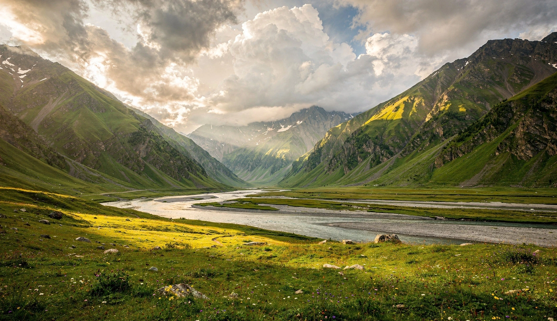
Everyone who visits the Kazbegi area does the Gergeti Trinity Church hike. It's beautiful, it's iconic, and it takes about three hours. But just over the other side of the Georgian Military Highway, a much quieter valley stretches 11 kilometers to the South Ossetian border, passing through a narrow gorge, past bubbling mineral springs that have painted the landscape orange, alongside abandoned stone villages, and ending at a medieval fortress on a hilltop. This is Truso Valley — and it might be the best easy day hike in the entire country.
Why Truso Valley Is Worth Your Time
The Kazbegi area is one of Georgia's most visited regions, and for good reason. But almost everyone gravitates toward Gergeti Trinity Church and maybe the glacier viewpoint above it. Truso Valley exists in a strange blind spot — it's not on the way to anywhere, the trailhead requires a short detour off the highway, and most tour operators don't mention it. Which is exactly why it's so good.
Unlike the Gergeti hike (which is essentially one big uphill followed by one big downhill), Truso is mostly flat. You walk along a jeep track through a valley that unfolds in stages. First, a narrow gorge with the Terek River crashing through. Then, the landscape opens into a wide alpine basin with views in every direction. Then it gets weird — orange and white travertine mineral deposits coating the hillsides, fizzing mineral lakes, the smell of sulfur. Medieval watchtowers appear on ridgelines. Crumbling stone villages sit silent in the grass. And at the far end, perched above it all, the remains of Zakagori Fortress guard the approach to the South Ossetian border.
It's one of those hikes where the scenery changes constantly, so you never get bored walking what is essentially a flat dirt road. The total elevation gain over 11 km is only about 400 meters — less than the Gergeti hike does in 3 km.
The Route: Section by Section
The trail follows a dirt jeep track the entire way, which means navigation is straightforward. You can't really get lost. The route runs along the Terek River (yes, the same river that flows all the way to the Caspian Sea via Russia) from the trailhead near Kvemo Okrokana village to Zakagori Fortress near the South Ossetian border.
| Section | Distance | Time | Highlights |
|---|---|---|---|
| Trailhead to Gorge Exit | ~2.5 km | 30–40 min | Narrow gorge, river crossings, canyon walls |
| Gorge Exit to Travertines | ~2 km | 25–35 min | Valley opens up, first mountain views |
| Travertines & Abano Lake | ~1.5 km | 30–45 min | Mineral springs, orange deposits, bubbling lake |
| Abano Lake to Ketrisi Village | ~2 km | 25–30 min | Abandoned village ruins, monastery |
| Ketrisi to Abano Village | ~1.5 km | 20–25 min | Seasonal village, small bar for drinks |
| Abano to Zakagori Fortress | ~1.5 km | 25–35 min | Fortress climb, border views, turnaround point |
The Gorge: A Dramatic Start
The hike begins at the bridge near Kvemo Okrokana, where a small parking area marks the start. You cross the bridge and immediately enter a narrow gorge. The Terek River churns through the gap, canyon walls rise on both sides, and the road hugs the left bank. It's instantly impressive — a sign that this isn't going to be a boring valley walk.
You'll cross the river twice on small bridges in the first couple of kilometers. After about 30 minutes, the gorge opens up and the valley widens dramatically. This transition — from tight canyon to sweeping alpine basin — is one of the best moments of the hike. Suddenly there are mountains in every direction, the river braids across a wide gravel bed, and the landscape feels enormous.
Driving the Gorge
4WD vehicles can drive most of the valley road, which means you'll occasionally share the path with jeeps and Land Cruisers. It's not annoying — maybe 5-10 vehicles on a busy day — but it's worth knowing that this isn't a wilderness trail. Some people drive to the travertines and hike from there.
The Travertines and Mineral Springs
About 4-5 km into the hike, you start noticing something unusual. The hillside on the right turns orange. Not autumn-leaves orange — chemical, mineral orange, like someone dumped a truck of rust over the landscape. These are the Truso travertines: calcium carbonate deposits built up over centuries by mineral-rich water seeping from underground springs.
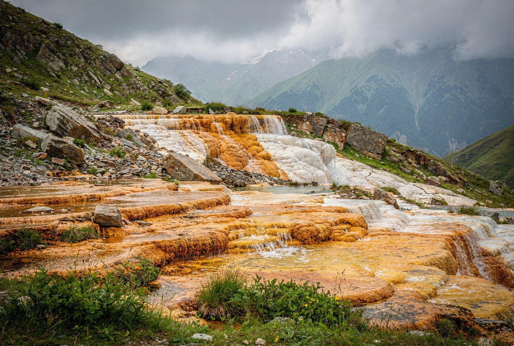
The colors are striking. White, orange, rust red, and pale yellow mineral formations cascade down the slopes. In places, small streams of mineral water flow over the deposits, adding fresh layers to formations that are probably thousands of years old. The smell of sulfur hangs in the air — not overpowering, but unmistakable.
Just past the main travertine area, you'll find Abano Mineral Lake — a small, slightly eerie pool fed by underground carbon dioxide springs. You can hear it before you see it: a quiet fizzing sound, like someone opened a giant bottle of sparkling water underground. The water bubbles constantly as CO2 escapes from below. Don't swim in it (despite what some travel blogs might imply) — the mineral content is extremely high and it's not safe for bathing.
The Geology
The Truso area sits on a geologically active zone. The mineral springs are caused by deep groundwater interacting with volcanic rock formations, picking up dissolved minerals (mainly calcium carbonate and iron) and CO2 gas as it rises to the surface. The same geological processes are responsible for the thermal springs in nearby Kazbegi.
The Abandoned Villages: Ketrisi and Abano
Past the travertines, the valley continues wide and open. Within a couple of kilometers you'll reach Ketrisi — or what's left of it. Most of the stone houses are in ruins, walls half-collapsed, roofs long gone. A monastery (St. 12 Apostles' Fathers) sits nearby, but the monks who live there seasonally aren't particularly welcoming to visitors, and there's nothing formal to visit. It's the kind of place where you just walk through and absorb the atmosphere: the scale of the mountains, the silence, the feeling that time has moved on without this village.
Another 1.5 km brings you to Abano Village, which is slightly more alive. A few families use the houses during summer months (roughly June through September), tending cattle and making cheese. There's usually a small bar or kiosk where you can buy drinks and basic snacks. Don't count on it being open — pack your own lunch.
The villages tell a common story in highland Georgia. These communities were once more populated, but decades of Soviet-era resettlement policies, harsh winters, and the pull of lowland cities have reduced most highland villages to seasonal outposts. Ketrisi is almost entirely abandoned; Abano hangs on by a thread.
Zakagori Fortress: The Turnaround Point
The trail's endpoint is Zakagori Fortress, perched on a hilltop about 1.5 km past Abano Village. This is the only real climb of the entire hike — a short, steep scramble up the grassy hillside to the fortress ruins. It takes maybe 10-15 minutes and your legs will remind you that you've already walked 10 km.
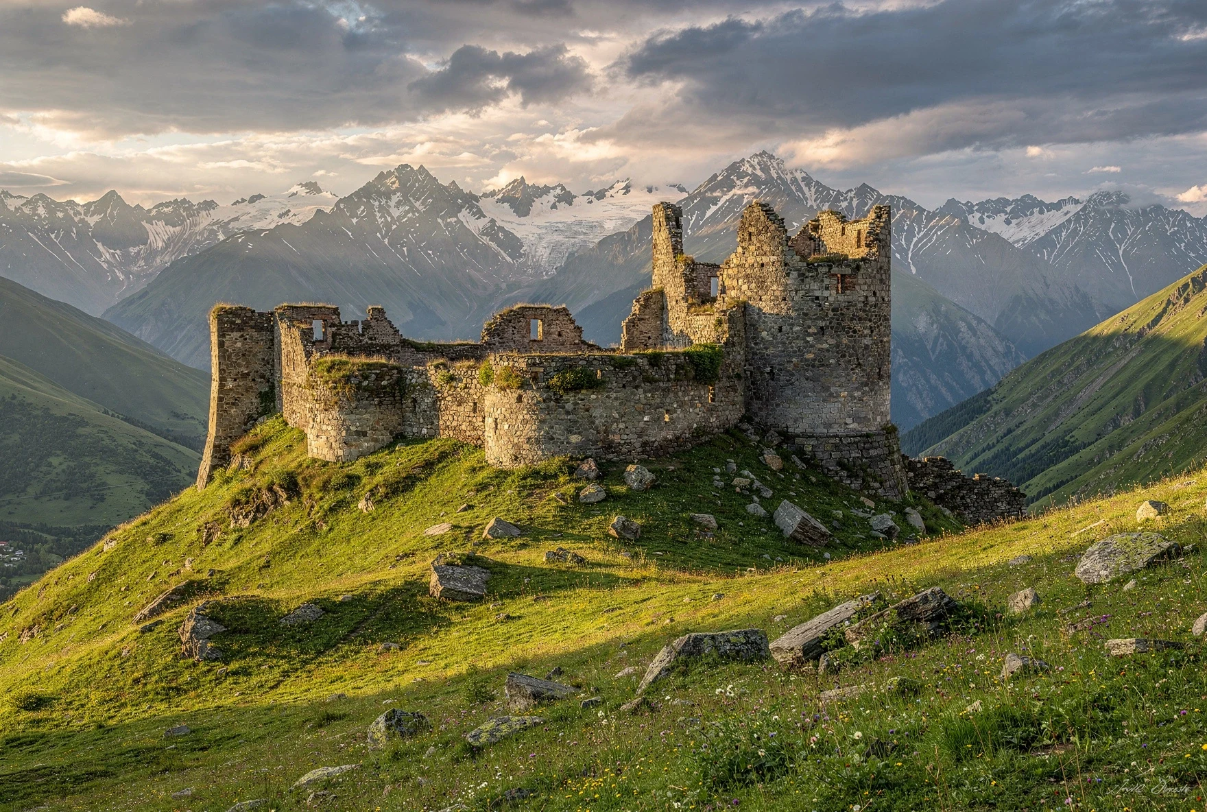
The fortress itself is fairly ruined — crumbling stone walls, no roof, no information plaques. Like many Georgian highland fortresses, nobody's entirely sure of its full history. What's certain is that it controlled the approach to the valley from the south, toward what is now South Ossetia. The border is close here — roughly a kilometer away — though there's nothing to see and no reason to approach it.
What makes the climb worthwhile is the view. From the top, you can see the entire Truso Valley spread out behind you — the flat green basin, the river, the patches of orange travertine, the mountains on either side. It's one of the best picnic spots in the Kazbegi area. Sit here, eat your lunch, and appreciate that you had the good sense to come here instead of waiting in line for a photo at Gergeti Trinity.
South Ossetia Border
The de facto border with South Ossetia is very close to Zakagori Fortress. Don't attempt to walk beyond the fortress area. There's no fence or visible border line, but the area beyond is controlled by Russian-backed forces. Georgian police occasionally patrol this section. Stick to the main trail and you'll be fine.
Difficulty and Fitness Level
Truso Valley is one of the easiest significant hikes in Georgia. If you can walk 22 km on mostly flat terrain, you can do this hike. The trail is a dirt jeep track the entire way — no scrambling, no route-finding, no exposed sections. The only real climb is the short hill to Zakagori Fortress.
What Makes It Easy
Flat terrain, clear jeep track, no navigation required, no technical sections. The altitude is moderate (2,000-2,200m) — much lower than nearby passes.
What Makes It Long
22 km round trip is still 22 km. Your feet will know about it by the return. No shade on most of the route. If it rains, the jeep track gets muddy.
| Factor | Rating | Notes |
|---|---|---|
| Overall Difficulty | Easy–Moderate | Length is the main challenge, not terrain |
| Terrain | Dirt road / jeep track | Some rocky sections, muddy when wet |
| Elevation Gain | ~400m total | Gradual — barely noticeable |
| Navigation | Impossible to get lost | One road, one direction |
| Altitude | 2,000–2,200m | Unlikely to cause altitude issues |
| Guide Needed? | No | Completely self-guided |
How to Get There
The trailhead is near the village of Kvemo Okrokana, which sits about 15 km south of Stepantsminda (Kazbegi) on the Georgian Military Highway. You can't walk from Kazbegi — you need a ride to the trailhead.
| Option | Cost | Time | Notes |
|---|---|---|---|
| Shared Transfer (Mountain Freaks) | ~$18/person | 45 min | Daily departures 9:15 AM and 11:15 AM from their Kazbegi office. Return pickups at 4:30 PM and 6:30 PM. Book 1-2 days ahead — seats fill up. |
| Private Taxi | 50–80 GEL one way | 40 min | Arrange through your guesthouse. Ask them to wait or agree on a pickup time. The road from the highway to the trailhead requires 4WD or high clearance. |
| Your Own Car (4WD) | Fuel only | 40 min | Turn left at Kobi (off the Georgian Military Highway). The 15-km gravel road to the trailhead is rough but passable for 4WD. Not recommended for sedans. |
| Hitchhiking | Free | Varies | Possible from Kobi junction. Limited traffic on the gravel road — could be waiting a while. |
From Tbilisi as a Day Trip
It's technically possible but brutal. Tbilisi to Kazbegi is 3 hours by marshrutka, then you need another 40 minutes to the trailhead. Better to stay overnight in Stepantsminda — it's a much better experience when you're not racing the clock.
When to Go
The hiking season for Truso Valley runs from June through October, with July through September being ideal. The road to the trailhead may be impassable earlier in spring due to snow and mud. By November, snow typically closes the valley for the season.
Best: July–September
Warm and dry (mostly). Longest daylight. Wildflowers peak in July. Abano village bar most likely to be open. Mountain Freaks transfers running daily.
Shoulder: June & October
June can be wet and the road may be muddy. October brings cooler temps and autumn colors but shorter days. Check conditions locally before heading out.
What to Bring
This isn't a technical hike, so you don't need serious gear. But 22 km on foot still requires some planning.
| Item | Why |
|---|---|
| 2+ liters of water | No reliable water sources. Don't drink from the mineral springs. |
| Packed lunch & snacks | The village bar may or may not be open. Bring your own food. |
| Sunscreen & hat | Almost no shade the entire route. At 2,000m+, UV is strong. |
| Rain jacket | Weather changes fast in the Caucasus. Afternoon storms are common. |
| Comfortable walking shoes | Trail runners are fine. Full hiking boots unnecessary unless it's wet. |
| Offline maps | No phone signal in the valley. Download Maps.me or OsmAnd beforehand. |
Budget Breakdown
Day Hike from Kazbegi (Per Person)
No Entry Fee
Unlike some Georgian parks and canyons, Truso Valley has no ticket office and no entry fee. It's free to hike. Just show up and walk.
Truso Valley vs. Gergeti Trinity Hike
If you only have one day in the Kazbegi area and you're trying to choose, here's an honest comparison:
| Factor | Truso Valley | Gergeti Trinity |
|---|---|---|
| Distance | 22 km round trip | ~6 km round trip |
| Duration | 5–7 hours | 2–3 hours |
| Difficulty | Easy (flat but long) | Moderate (steep but short) |
| Crowds | Very few people | Busy (100+ people/day in summer) |
| Icon Factor | Unknown, raw, different | Georgia's most famous view |
| Variety | Gorge, springs, ruins, fortress | One church, one view (a great one) |
| Transport Needed | Yes (to trailhead) | No (walk from town) |
The honest answer: do both. Gergeti on one day, Truso on the next. They're completely different experiences. If you only have one day, do Gergeti — it's the signature Georgia experience. But if you have two days (and you should), Truso is the reward for anyone willing to go a little further off the beaten path.
Practical Tips
Start Early
Take the 9:15 AM transfer if using Mountain Freaks. Starting early gives you the most time and the best light for photography. Afternoon storms are common in summer.
No Phone Signal
There's zero mobile coverage once you enter the valley. Download offline maps before you go. Tell someone at your guesthouse where you're headed.
Take Your Trash
There are no bins in the valley. Pack out everything you bring in. Georgia's hiking trails are generally clean — let's keep it that way.
Respect the Monasteries
The monks at the valley monasteries value their privacy. Don't try to enter or photograph them up close. A respectful distance photo is fine.
Camping is Possible
If you want to spend more time, camping near the travertines or Abano village is stunning. Bring all your own supplies — there's nothing to buy in the valley.
Dogs
Shepherd dogs protect livestock in the valley. They're usually docile but can be territorial. Keep your distance from flocks, especially if dogs are present. Don't run.
Combining with Other Kazbegi Hikes
If you're spending multiple days in the Kazbegi area (which you should), Truso Valley fits perfectly into a 2-3 day itinerary:
Suggested 2-Day Kazbegi Plan
For a three-day itinerary, you could add the Juta to Roshka trek via Chaukhi Pass — though that's a significantly harder hike that requires camping or arranging transport from Roshka.
Frequently Asked Questions
Do I need a guide for Truso Valley?
No. The trail is a single jeep track — impossible to get lost. A guide adds nothing unless you want historical commentary.
Can I drive instead of hiking?
Yes, with a 4WD vehicle you can drive to the travertines and even further. But you'll miss the gorge section and honestly, the walk is the point. Drive if you're short on time or mobility.
Is it safe near the South Ossetia border?
Yes. The trail stays well within Georgian-controlled territory. Don't walk past Zakagori Fortress, and you'll have zero issues. Thousands of tourists hike here every summer.
Can I swim in Abano Mineral Lake?
No. The mineral content is very high and CO2 bubbles from below. It's not a swimming spot — it's a geological feature. Just admire it.
Is Truso Valley doable as a day trip from Tbilisi?
Technically yes, but it's a very long day: 3 hours to Kazbegi, 40 minutes to the trailhead, 5-7 hours hiking, then 3+ hours back. You'd be out for 14+ hours. Stay overnight in Stepantsminda instead.
Written by The Georgian Guide Team
We've hiked Truso Valley multiple times across different seasons and always recommend it as the best alternative to the crowded Gergeti hike. It's one of those places that rewards the people who bother to go a little further.
Last updated: February 2026.
Related Articles
Kazbegi (Stepantsminda) Guide
The complete guide to Georgia's most dramatic mountain town.
Juta to Roshka via Chaukhi Pass
Georgia's best multi-day trek through the "Georgian Dolomites."
The Georgian Military Highway
The legendary road from Tbilisi to Kazbegi — and how to drive it.
Best Hikes in Georgia
Our picks for the top trails across the country.